|
Reported Crop Circles for the State
of North
Carolina -
Burnsville, Yancey County (July 2, 2005)
This formation was spotted by ICCRA member Jeffrey Wilson on a photo flight while flying a plotted line connecting three previously reported North Carolina formations; this formation was just off the line slightly to the southeast.
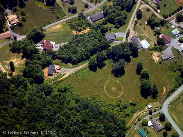
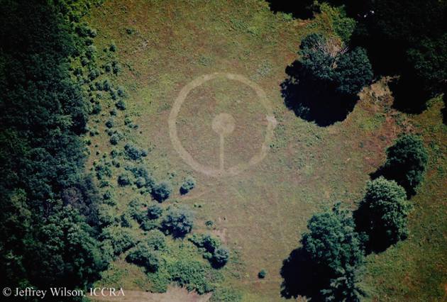
The formation consisted of a 110 diameter ring with a 22 diameter circle with a connecting path to the ring. The formation was swirled counter-clockwise in grass.
The formation was located on a steep hillside, and overlooking a running creek at the bottom of the hill. The formation was also below power lines at the top of the hill. Four of the five closest poles had transformer boxes on them (including the closest one).
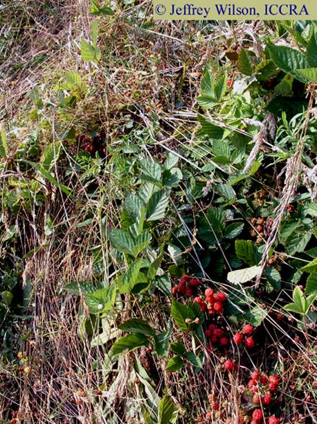
The formation, interestingly, flattened a number of blackberry bushes located in the pathway of the formation without damaging any of the berries.
The landowners had not noticed the formation in their field until ICCRA members arrived to tell them about it - no signs of human footprints, obvious mechanical damage or hoaxing marks were found in the field. The formation appeared to be almost a week old judging by the plants recovery.
ICCRA members collected plant and soil samples from this formation for later analysis, and made E-M and radiation measurements. This formation tested L-NEAT positive for node elongation, and while at the formation, ICCRA members detected statistically higher levels of radioactivity with a GammaScout Geiger counter. No E-M differences were detected, but the radiation readings seem to mirror the 4-circle Leicester, North Carolina formation found only a couple of weeks earlier, with a slight increase in radiation measurements from inside the formation.
Crop
type: field grass and brambles
Sources: ICCRA investigation
Photos: Jeffrey Wilson |
|
City
/ County / Date:
- [Unknown] (Nov 1919)
- Lumberton,
Robeson County (August 27, 1952)
- Asheboro,
Randolph County (August 18, 1953)
- Mount Airy, Surry County, NC (August 19, 1965)
-
High Point, Guilford County
(March 23, 1974)
-
Greensboro, Guilford County (June 16, 1975)
-
Little Pisgah Mountain, Hendersonville, Henderson County
(April, 1979)
- Mocksville, Rowan County (November, 1985)
-
Vale, Lincoln County
(September, 1990)
-
Charlotte, Mecklenburg County (September, 1990)
-
Asheboro, Randolph County (October 11, 1990)
-
Charlotte, Mecklenburg County (August 8, 1991)
- Raeford, Hoke County
(June 27, 1992)
- Gastonia, Gaston County
(April 30, 1994)
- Black Mountain, Buncombe County (June 17, 1994)
- Hertford, Perquimans County (June 11, 1997)
- Unionville, Union County
(May 9, 1998)
- Dudley, Wayne County
(May 26, 2004)
-
Hickory, Catawba County
(May 3, 2005)
-
Green Mountain, Yancey County (June 11, 2005)
-
Green Mountain, Yancey County (June 20, 2005)
- Leicester, Buncombe County #1 (June 21, 2005)
- Leicester, Buncombe County #2 (June 21, 2005)
-
Jupiter, Madison County
(June 21, 2005)
-
Burnsville, Yancey County
(July 2, 2005)
-
Leicester, Buncombe County (July 5, 2005)
-
Mars Hill, Madison County
(July 9, 2005)
|


